Raising Clarrie Hall Dam
To provide for our growing population, Tweed Shire Council is sustainably upgrading and expanding our water and wastewater systems. This involves projects to secure a sustainable water supply so the Tweed’s people and places can thrive.
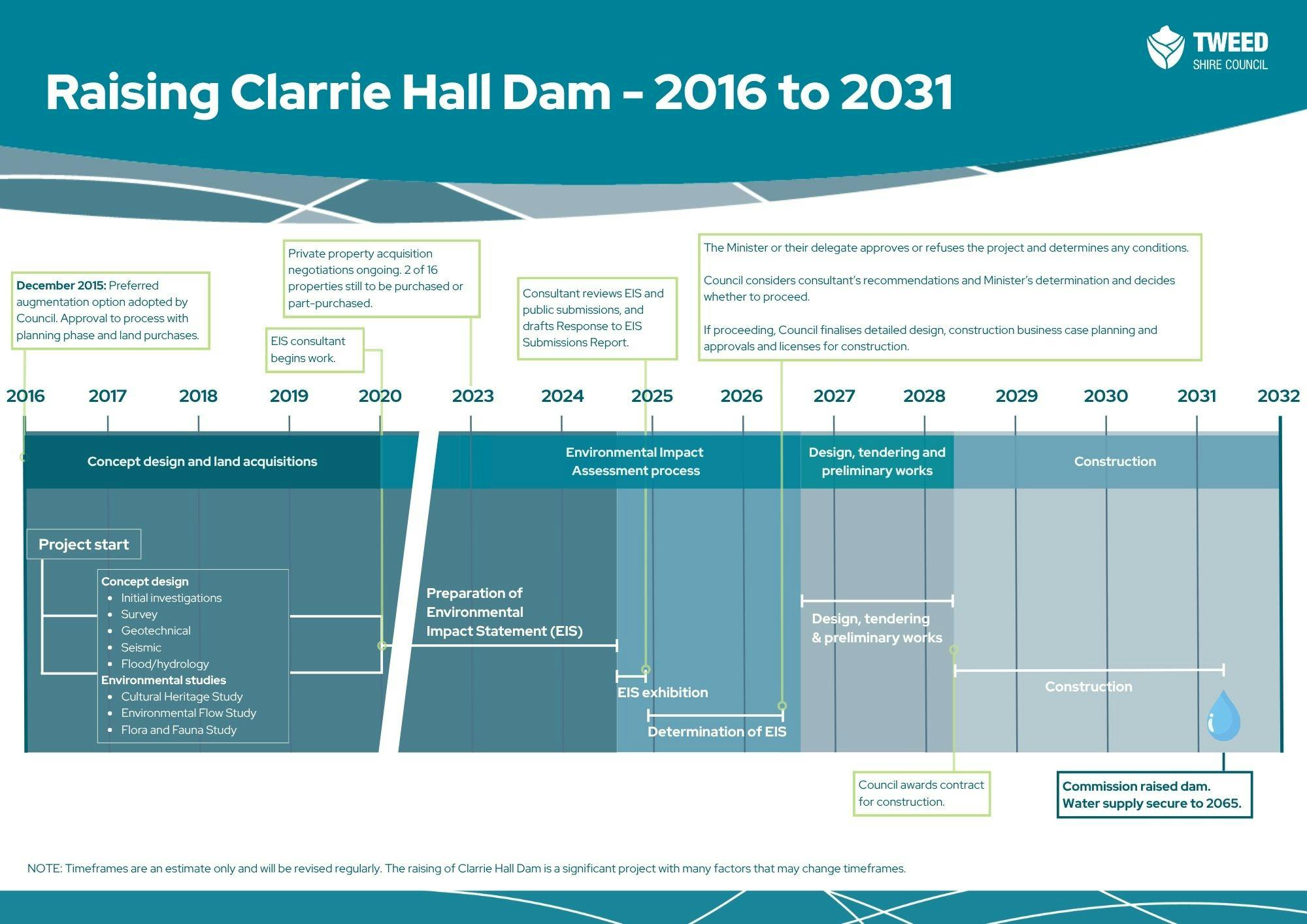
One of those projects is increasing the storage of Clarrie Hall Dam by raising the dam wall. In December 2015, Council resolved to undertake the planning and land acquisition for the proposed raising of the dam.
It is proposed to raise the dam wall by 8.5 metres to a height of 70 metres Australian Height Datum (AHD RL70). This would:
- increase the size of the dam from 16,000 megalitres (ML) to about 42,300 ML
- secure our water supply until at least 2065.
Current stage of the proposal: Determination of the EIS
The NSW Department of Planning, Housing and Infrastructure publicly exhibited the Environmental Impact Statement (EIS) from 25 September to 6 November 2024. Thank you to everyone who made a submission.
Council reviewed the submissions and prepared an extensive Response to Submissions report, which was provided (along with the EIS and submissions) to the Minister for Planning and Public Spaces in late 2025.
In 2026, the Minister will decide whether our proposal to raise the dam can go ahead and what conditions would apply.
If the Minister determines the project can proceed, the elected Council would consider consultant recommendations and the Minister’s determination, and decide whether to proceed. If they decide to proceed, we would undertake business case planning for detailed design and construction, and seek approvals and licences for construction.
Why this proposal is needed
Water is an essential service. Reliable access to water offers us a sense of safety at home and is the foundation of a healthy community.
Population growth
Through Council’s water-efficiency initiatives, the average Tweed resident has in recent decades reduced their demand for water by more than 20%. This has allowed Council to service our growing population without increasing the amount of water we draw from the Tweed River.
Tweed's existing water supply is forecast to be able to meet demand until at least 2030. Council chose to raise Clarrie Hall Dam to increase its storage capacity, and proceed with planning approval and land acquisitions for the project.
Raising the dam wall will almost triple the dam’s capacity and double its footprint, securing our water supply until at least 2065.
Climate change
Climate change is causing more frequent extreme weather events, including droughts. A larger dam will help reduce the risk of water shortages.
Related water security projects
Council is committed to planning for a secure long-term water supply that suits the Tweed community. To ensure this, we have worked with the community to review all our water strategies, including Demand Management (Water Efficiency), Water Augmentation and Drought Management Strategy. A report on these matters was received by Council in March 2021.
Since then, Council has adopted all recommendations made by the community project reference group (PRG), updated its Drought and Water Restrictions Policy and progressed its future water supply strategy. Raising Clarrie Hall Dam is a key part of this strategy. For more information, visit our future water supply webpage.
In late 2023, Council engaged consultant GHD to prepare an Integrated Water Cycle Management (IWCM) Issues Paper. The Issues Paper considers all aspects of Council’s water and wastewater services, including infrastructure, performance, financial planning, asset management and future planning. It also assesses Council’s recycled water and demand management strategies. Read more about the Integrated Water Cycle Management.
Bray Park Weir Tidal Protection Project
Most of the Tweed’s tap water is sourced from the Tweed River at the Bray Park Weir.
In addition to causing more frequent extreme weather events, climate change is causing sea levels to rise and reducing the flow of water in the Tweed River. The rise in sea levels is increasing the risk of tidal salt water and sea-level anomalies overtopping the Bray Park Weir, which could affect the quality of our water supply.
Council is developing and assessing options to mitigate this risk. Head to our Bray Park Weir Tidal Protection Project page to find out more.
Water link to City of Gold Coast
The pipeline provides an emergency supply in the event of a gross failure of the Tweed District water supply due to infrastructure failure.
The pipeline does not negate the need to raise Clarrie Hall Dam.

-
New bridge to keep Commissioners Creek connected
Thursday 26 April 2018
Council last week adopted a recommendation to build a new bridge parallel to the existing McCabe’s Bridge at Doon Doon to provide road access to residents of Commissioners Creek after the wall of Clarrie Hall Dam is raised.
The decision followed a number of studies and 12 months’ consultation with the affected residents. The residents nominated a new bridge as their preferred option at a stakeholder meeting at Doon Doon Hall on Tuesday 20 March.
The residents’ preference was presented to Council as the preferred option and adopted unanimously.
Council will now beginContinue reading

Videos
-
Explanatory video about the proposal to raise the wall of Clarrie Hall Dam.